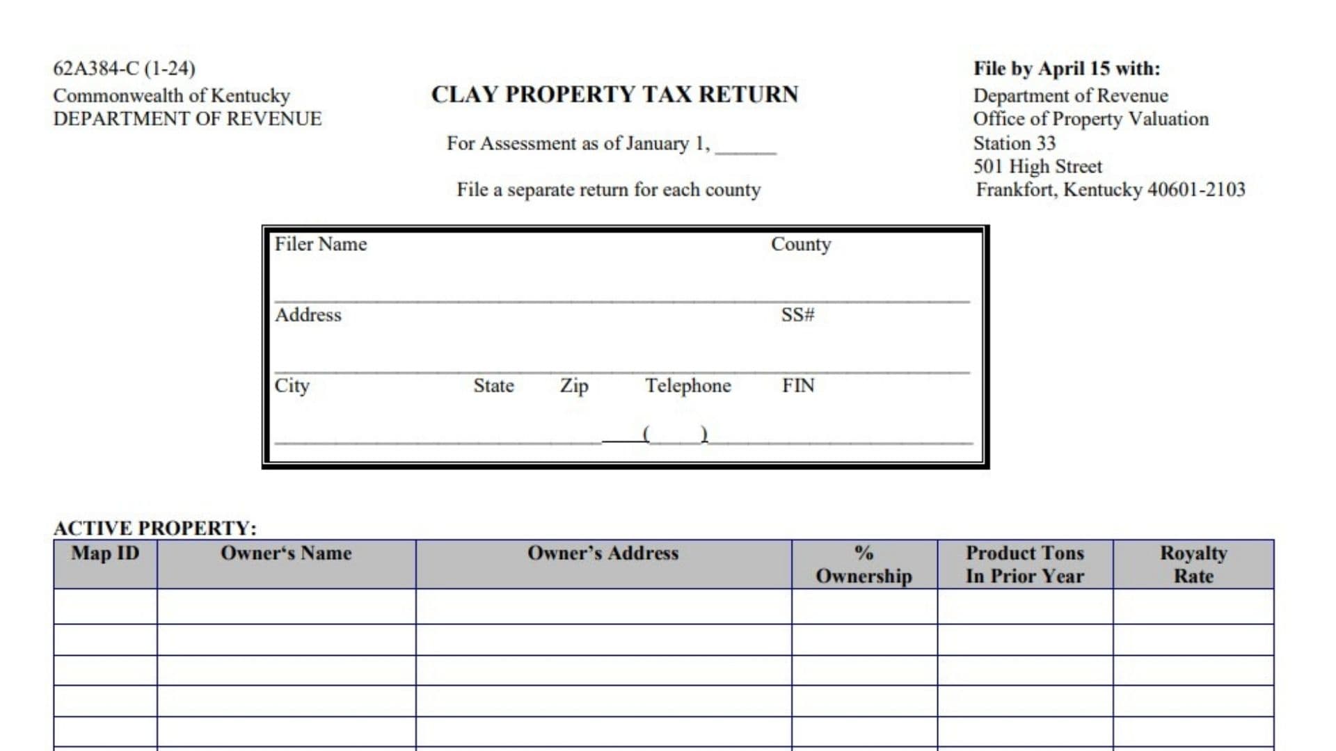
The Kentucky Clay Property Tax Return is a property reporting form used to provide the Kentucky Department of Revenue with information about clay-related property interests for property tax assessment purposes. The return is prepared for an assessment date of January 1 and asks the filer to report identifying information along with details about active clay property, inactive clay property, leases that ended during the previous year, and clay property that was sold or purchased during the previous year. Instead of combining property located in different counties on one return, the form requires a separate return for each county. This means a filer with reportable clay property in more than one Kentucky county should prepare an individual return for each applicable county. The form also requests ownership information, property map identification numbers, production figures for active property, royalty rates, permitted and idle acreage for inactive property, information about terminated leases, and transaction details for property bought or sold. At the end of the return, an authorized person must verify that the information supplied, including any schedules, statements, maps, and supporting documentation incorporated with the return, is accurate and complete to the best of that person’s knowledge. Because the information reported can affect the assessment of clay-related property interests, each entry should be completed carefully and consistently with the filer’s property, production, ownership, lease, and transaction records.
How To File The Kentucky Clay Property Tax Return
The return states that it should be filed by April 15. Prepare the information using the January 1 assessment date shown at the top of the form.
A separate return should be prepared for each county. If clay property interests are located in multiple counties, do not combine all of those counties on one return.
After completing the applicable property sections and signing the verification area, submit the return to:
Kentucky Department of Revenue
Office of Property Valuation
Station 33
501 High Street
Frankfort, Kentucky 40601-2103
Before submitting the return, review the filer information, property tables, ownership percentages, production amounts, acreage, transaction values, and signatures for completeness.

How To Complete The Kentucky Clay Property Tax Return Line By Line
Form Identification And Assessment Information
Form Number
The return is identified as Form 62A384-C. This identifies the specific Kentucky tax return being completed for clay property.
Commonwealth Of Kentucky
This identifies the return as a Kentucky state filing.
Department Of Revenue
The Kentucky Department of Revenue is the state agency associated with the return.
Clay Property Tax Return
This is the name of the return. Use it to distinguish this filing from other property tax forms that may apply to different types of property.
For Assessment As Of January 1
Enter the year that applies to the January 1 assessment date.
For example, if you are reporting property for the January 1, 2026 assessment date, enter 2026 in the blank.
The information reported should correspond to the appropriate assessment period and the reporting categories requested by the return.
File A Separate Return For Each County
Prepare one return for each county in which the clay property being reported is located.
Do not place properties from several counties on the same county return.
Filing Destination And Deadline
File By April 15
The return gives April 15 as the filing deadline. Complete and submit the return by that date.
Department Of Revenue
Submit the completed return to the Kentucky Department of Revenue.
Office Of Property Valuation
The return is directed to the Office of Property Valuation within the Department of Revenue.
Station 33
Include Station 33 as part of the mailing information.
501 High Street
Use 501 High Street as the street address shown for filing.
Frankfort, Kentucky 40601-2103
Complete the mailing address with Frankfort, Kentucky 40601-2103.
Filer Information
The identification box near the beginning of the return tells the Department of Revenue who is filing and which county the return covers.
Filer Name
Enter the full legal name of the individual, business, or other filer responsible for submitting the return.
Use a name that matches the filer’s tax and business records.
County
Enter the Kentucky county covered by this particular return.
Because a separate return is required for each county, only property associated with the county entered here should be reported on this return.
Address
Enter the filer’s mailing or business address.
Make sure the address is complete enough for correspondence related to the return.
SS#
Enter the applicable Social Security number when the filing is associated with an individual and this identification number is required for the filer.
Double-check the number before submitting the return because identification errors may make it harder to match the filing with the correct taxpayer.
City
Enter the city associated with the filer’s address.
State
Enter the appropriate state abbreviation for the filer’s address.
Zip
Enter the ZIP Code associated with the mailing address.
Include the full applicable ZIP Code so the address information is complete.
Telephone
Enter a telephone number where the filer or an appropriate contact person can be reached.
The form provides a standard telephone-number format with an area code.
FIN
Enter the applicable federal identification number for the filer when relevant.
Use the identification number associated with the person or entity responsible for the return.
Active Property
Use this section to report clay property that is considered active for the reporting period.
Each separate property or ownership interest should generally be entered on its own row so the information in the columns corresponds to the same property.
Map ID
Enter the map identification number assigned to the property.
Use the property identifier associated with the parcel or clay property interest being reported.
Owner’s Name
Enter the name of the property owner associated with the Map ID listed on that row.
Use the owner’s full name or the legal name of the owning entity.
Owner’s Address
Enter the owner’s mailing address.
Be sure the address corresponds to the owner listed in the previous column.
% Ownership
Enter the percentage of the property interest owned by the person or entity being reported.
For example, if the reported owner holds half of the relevant ownership interest, enter the appropriate percentage representing that ownership share.
Do not automatically enter 100% if the property has multiple owners.
Product Tons In Prior Year
Enter the number of tons of clay product associated with the property during the previous year.
Use the production records that correspond to the property entered on that row.
The figure should represent tonnage rather than a dollar amount.
Royalty Rate
Enter the royalty rate associated with the clay property.
Use the applicable rate from the relevant ownership, lease, royalty, or operating records.
If different properties have different royalty arrangements, report the appropriate rate separately for each property row.
Inactive Property
Use this section for clay property that is inactive rather than currently reported in the active-property section.
Each inactive property should be entered separately.
Map ID
Enter the map identification number for the inactive property.
Use the same type of parcel or property identifier used in the active-property section.
Owner’s Name
Enter the full name of the owner of the inactive property.
Owner’s Address
Enter the mailing address of the owner listed for that property.
% Ownership
Enter the percentage of ownership associated with the reported owner.
If the ownership is shared, report the percentage that applies to the ownership interest being listed.
Permitted Acres
Enter the number of acres covered by the applicable permit for the property.
Use acreage records associated with the property and its permitted area.
Idle Acreage
Enter the acreage that is idle for the property being reported.
Keep this amount separate from the permitted-acre figure because the form requests the two measurements in different columns.
Lease Terminated During The Prior Year
Complete this section when a clay property lease ended during the previous year.
Report each terminated lease on a separate row when more than one termination must be reported.
Map ID
Enter the map identification number associated with the property whose lease was terminated.
Owner’s Name
Enter the name of the property owner connected with the terminated lease.
Owner’s Address
Enter the owner’s address.
Use the address corresponding to the owner shown on the same row.
Acres
Enter the number of acres connected with the terminated lease.
Use the acreage associated with the property or lease interest being reported.
Reason For Termination
Briefly state why the lease ended.
Use a clear and accurate description that reflects the circumstances shown in the relevant lease or property records.
Keep the explanation concise because this column is designed for a short reason rather than a lengthy narrative.
Property Sold Or Purchased During The Prior Year
Use this section to report applicable clay property that was sold or purchased during the previous year.
Enter each transaction separately so that the property identifier, parties, values, and recording information all relate to the same transaction.
Map ID
Enter the map identification number of the property involved in the sale or purchase.
Grantor
Enter the name of the grantor.
The grantor is generally the party transferring the property interest in the transaction.
Use the legal name shown in the transaction records.
Grantee
Enter the name of the grantee.
The grantee is generally the party receiving the property interest.
Enter the legal name associated with the acquisition.
Total Value
Enter the total value associated with the property transaction.
Use the amount supported by the applicable transaction documentation.
Clay Value
Enter the portion of the property’s value that is attributable to the clay interest being reported.
Keep this figure separate from the total property value because the return requests both values individually.
Db/Pg
Enter the deed book and page information associated with the recorded property transaction.
Use the recording reference shown in the applicable deed or property records so the transaction can be connected to its recorded documentation.
Verification
The verification section is the filer’s formal confirmation that the return has been reviewed and that the information being submitted is complete and accurate.
By signing the return, the signer affirms, under penalties of perjury, that the report has been examined, including the schedules, statements, and maps that accompany it, and that the information is true, correct, and complete to the best of the signer’s knowledge, information, and belief.
The verification also provides that documentation supporting an assessment or requesting an assessment is treated as incorporated into the return and becomes part of the filing.
Review all sections carefully before signing. Make sure any information supplied with the return is consistent with the figures and property details entered on the form.
Authorized Signature
The authorized person responsible for the filing should sign here.
The signer should review the completed return before signing because the signature confirms the accuracy and completeness of the information submitted.
Preparer’s Signature
If another person prepared the return, that preparer should sign in this space.
This line identifies the person who prepared the filing when that person is different from the authorized signer.
Date
Enter the date the return is signed.
Use the date associated with the completed verification and signatures.
Final Review Before Filing
Before submitting the Kentucky Clay Property Tax Return, confirm that the correct assessment year has been entered and that the return covers only one county. Check the filer name, address, county, identification numbers, telephone number, and all applicable property tables. Make sure active property includes the correct map IDs, ownership details, prior-year production tonnage, and royalty rates. Review inactive property for ownership, permitted acreage, and idle acreage. If any leases ended during the previous year, confirm that the property, acreage, and termination reason are included. If property was sold or purchased, verify the grantor, grantee, total value, clay value, and deed book and page information. Finally, review the verification section, obtain the required signatures, enter the signing date, and submit the completed return by the stated filing deadline.